Google Goes to Haida Gwaii
Published in EXPLORE Magazine
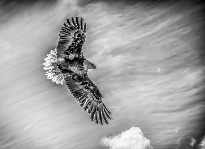
The woods surrounding the long abandoned Haida village site of Kiusta are lovely, dark and deep. Shafts of sunlight probe this ancient rainforest’s dense emerald membrane of moss and lichens like celestial searchlights. Bald eagles, one of the two moieties of Haida society along with ravens, surf the thermals high above.
Here, on the edge of Xhaaidlagha Gwaayaai, the ‘Islands at the Edge of the World’ in the language of this mist shrouded archipelago's early inhabitants, indents in the soil, decayed red cedar longhouse beams and the remnants of a chief’s mortuary totem pole stand guard over the spirits. Amid them, shore pines with bizarrely horizontal branches sprout from the soil.
“We call them spirit trees because the only place we ever see them is in our old villages,” says Max Collison, a Haida Watchman who has agreed to show me this remote ruin on the northwestern tip of Graham Island, across from Langara Island. Assigned to protect important cultural sites, Watchmen like Max, a Raven Clan member, also interpret the myriad mysteries of Haida culture to visitors. “We believe that our ancestors come through the roots in the ground and up through these trees,” he adds, “reaching out to us from the past.”
Once home to a population of around three hundred, Kiusta - which means ‘Where the tail comes out’ in Haida, was abandoned in the 1850s during one of the devastating smallpox epidemics that ravaged Haida Gwaii’s population after first contact Europeans in the late 18th century. I’ve journeyed here from Vancouver by charter jet, helicopter, fishing boat and outboard launch. Soon, you won’t have to venture further than your computer monitor or smartphone to savour the elemental beauty of this sacred spot. That’s because Google’s Trekker visually mapping technology has arrived in Haida Gwaii.
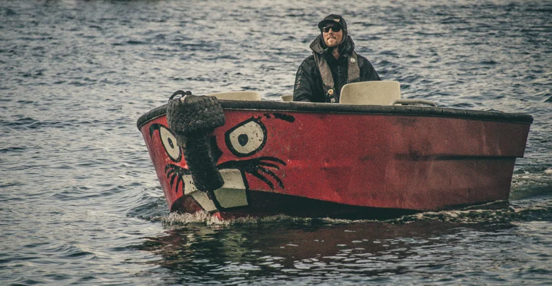
Following Max and me through the meandering forest trail between Kiusta and nearby Lepas Bay is a sturdy young man with an unwieldy apparatus on his back that weighs some twenty kilos. Tyler Clarke works for Northern BC Tourism, to which Google has lent out one of its precious Trekkers for the summer. Powered by brick-sized batteries carried in said backpack connected by a metal arm to a soccer ball sized sphere perched above its operator’s head, Trekker’s 15 cameras can snap 360-degree panoramic photos every 2.5 seconds. They’re saved to hard drives, then periodically sent to Google headquarters and eventually uploaded to Google Maps. It’s basically the off-road version of Google Street View, a Google Maps and Google Earth feature that offers panoramic views along many streets around the world.
The oddly retro Google Trekker resembles a clumsy contraption straight out of a 1950s sci fi flick, and yet is mobile enough to go pretty much anywhere its operator can carry it. This mobility allows its cameras to capture hiking trails, wilderness areas and historic sites inaccessible to vehicles. To date, Trekker has traversed over 1,500 kilometers of British Columbia, including the coast of Haida Gwaii, Tumbler Ridge Global Geopark and Ancient Forest/Chun T’oh Wudujut, part of the world’s only known inland temperate rainforest. Trekker has also photographed Banff, Ivvavik, Wood Buffalo, Cape Breton and Tuktut Nogait National Parks, as well as Labrador’s Torngat Mountains.
We emerge from the trail at a wide stretch of sandy beach on Lepas Bay, departure point for a challenging fifty kilometre long shoreline hiking trail. . Black oystercatchers and Leach’s storm-petrels animate the nearly cloudless afternoon skies above nearby Lepas Bay Ecological Reserve, a rocky, 3.6 square kilometre island created to preserve the habitat of these and other nesting seabirds. For thousands of years, Haida fishermen launched their enormous dugout canoes from this storm pummelled bay. Debris from the 2011 Japanese tsunami, including glass-blown fishnet floats that are eBay collectors’ items, still occasionally washes up here. Wild and remote, this stretch of Graham Island is the most westerly point in all of Canada.
As we walk, Max points to a Haida Rediscovery Camp across Lepas Bay, one of several built to combat the effects of chronic substance abuse, juvenile delinquency and generational family disruption on Haida youth. With the advice and guidance of Haida elders, Max and his fellow Watchmen help staff them during summers. The goal is to foster in their teen and preteen participants a deeper connection to their ancestral land and heritage through wilderness skills training, traditional activities and rich cultural immersion.
“We teach the children songs, how to prepare food, and our language,” says Max. “We also share Haida myths and stories, and teach carving and other arts.” He clearly cherishes this opportunity to connect with Haida youth. In his mid-fifties, this man who survived a hard, self-destructive youth is now a grandfather, a chinnie in the Haida language. “Right now I miss all the little ones,” he tells me. “Especially my ten year old granddaughter, who lives in Vancouver but comes up every summer. She’s my world.”
Tyler and Max will return to Lepas Bay the next afternoon to photograph more of its craggy coastline - including the Haida Rediscovery Camp. Once online these images will join those of other world famous destinations like Cambodia’s Angkor Wat, the Taj Mahal and the Galapagos Islands. Google Trekkers have also photographed farflung attractions like the Northern Lights in Finland’s Pitkäjärvi Lake, the Avenue of Baobabs in Madagascar's Andranomena Special Reserve, the Atol das Rocas in the South Atlantic Ocean, Hövsgöl Nuur, a lake in Mongolia near the Russian border, and Kenya’s Samburu Game Reserve. Someday, the entire world may be viewable online, thanks to Google. Is that a good thing?
When I started backpacking in the mid-1980s, some peripatetic purists dismissed Lonely Planet and other early guidebooks as fostering cheating, their way finding information making independent travel too easy, safe and predictable. Then came the Internet with its ever spreading umbilical tentacles. And smartphones that let travellers almost constantly remain connected with home, no matter where in the world they were. Now there’s the tsunami of selfies from sexy places feeding the insatiable appetites of Instagram, Flickr, Facebook and Google.
Is there anywhere left to hide? Is Trekker snuffing out some of adventure travel’s essential magic and mystery, from the coast of Haida Gwaii to the length of Nepal’s Annapurna Circuit? When you can fully preview virtually every step of a route or destination in 360 degrees of digitally enhanced detail, what have you lost before you’ve even arrived? If it’s the journey, not the destination, that really matters, are technologies like Trekker friend or foe? For tourism organizations like Destination BC, the pros outweigh any cons. By exploiting Google’s Street View capability in Trekker and mapping the wilderness of British Columbia, they say they are providing audiences with an unprecedented opportunity to virtually experience our wild places.
This, argue proponents like Clint Fraser, head of Northern BC Tourism, will hopefully inspiring many more people to consider exploring. “Trekker is a very visual tool and we know that the more we can immerse a user in our content the more likely they are to plan a visit,” Fraser says. “People generally understand that experiencing some of these areas virtually does not compare to the experience you have when your feet are actually on the ground. If we can provide a little virtual taste through initiatives like this we are certain that it will go a long way in inspiring them to visit the destination for more.”
One could also argue that the more people understand about a destination, the more prepared they may be once they reach it. And that an increase in trail traffic could lead to more awareness of the fragility of our remaining natural places, spurring greater efforts to preserve these precious places for future generations. What about people who can’t travel because of limited resources, poor health or physical limitations? Trekker’s images can nourish their imaginations and help them feel more connected to the wider world.
The same goes for people living in Trekker’s path. As a Haida Watchman, charged with preventing historically significant Haida sites like Kiusta from being vandalized and their artifacts stolen, Max Collison is a proud custodian of a precious and fragile past. But he’s not so protective that he doesn’t welcome the arrival of technologies like Trekker, which will expose his beloved home to potentially billions of people around the world. "I;m very excited about this project because the more people who know about this place the more exciting our job will be,” he assures me. “People in all parts of the world will soon be able to see this footage and feel almost like they're here, maybe motivating them to save up to come here for real someday.”
Max also points to a major distinction between the Google Trekker team and earlier outsiders who visited Haida Gwaii hoping to take a piece of it home. “Howard Hughes once came here to source the materials for the Spruce Goose,” he says, referring to the eccentric aviator’s wooden behemoth, the largest aircraft ever built. “Mr. Hughes didn’t ask permission and so a Haida curse was placed upon him,” Max continues. “Where is he now? Gone and nowhere to be found. It’s different for you guys because you asked for permission.”
That evening, we invite Max to join the members of Team Trekker for dinner at Langara Island Lodge, the posh fishing camp we’re using as our base of optical operations. Operating since the mid 198os, this luxury property caters to well-heeled corporate clients, including CEOs, their families and entourages, offering them some of the best salmon and halibut fishing in the world. Guests arrive by helicopter from Masset airport, about a half hour’s flight south. Most depart a few days later having caught their limit, delivered cleaned, filleted, vacuum-packed and flash-frozen fish to them upon their departure.
Over a surf and turf at Langara’s Eagle Lodge, Max shares stories about his youth, like the time his parents hid him on a fishing boat when government officials seized many native children for relocation to residential schools elsewhere in BC and Alberta. “When my friends came back from those schools everything had changed. They were not the same people,” Max says. “But we just accepted them for who they now were and hoped that they would eventually change their ways and return to our culture.”
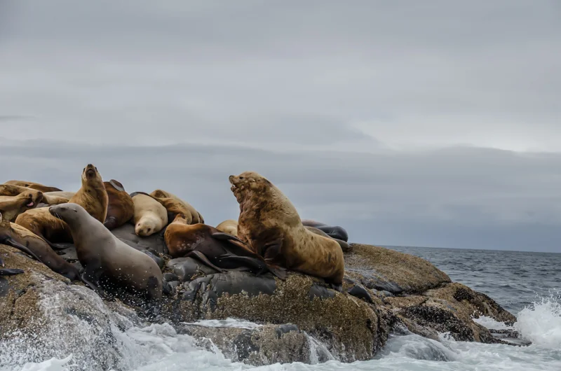
The next morning, we’re photographing a colony of sea lions from one of the lodge’s boats. Flopping onto rocks beneath Langara Point Lighthouse, the only manned lighthouse still operating on the northern B.C. coast, they bark incessantly. Here, on the most northerly tip of Haida Gwaii, New World first encountered Old in the summer of 1774 when a group of Haida paddled out to greet Spanish explorer Juan José Pérez Hernández. He later named the island he ‘discovered’ after Spanish naval commander Juan de Lángara.
Trekker strapped on his back, Tyler steadies himself at the bow while Google’s contribution to cartography records the island’s pinniped-packed shoreline. Suddenly, we learn that a pod of humpback whales has been spotted bubble net feeding a few miles offshore. Keen to witness this spectacular marine spectacle, we speed off in their direction. Soon, we’re observing the pod swimming in an ever shrinking circle, blowing bubbles beneath a large school of fish to force them upward. Then the whales rise in unison to breach the ocean’s surface, their gaping mouths devouring thousands of fish in a single gulp.
Bubble net feeding is an epic demonstration of synchronized fishing, but we can’t get close enough for Trekker to properly record the spectacle. These whales won’t end up on Google Maps just yet, but the geniuses in the company’s Mountain View, California headquarters are likely already hard at work prototyping a Trekker-fitted submarine. Hopefully, it will be one large enough to also accommodate a Haida Watchman. Such is the relentless advance of technology, now even impacting the timeless worlds of Ravens and Eagles on these magnificent islands at the edge of the world.